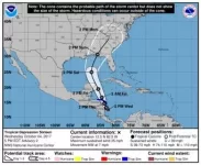
New NHC Cone, Tropical Depression 16 forms (NATE)

One extra thing to add is that (RI) Rapid Intensification is not off of the table. If the system doesn't interact with land it will be sitting over the warmest waters in the basin with little to no shear or dry air. In the short term W Carib/S Gulf this thing could blow up rather quickly (important note: not an Irma) and become stronger than currently forecast by the NHC.
Get a life kid. Don't you have anything better to do than guess at what may or may not happen pertaining to weather and game. You are pathetic. If we play, fine. If we don't play, so be it.

Um....ok? That wasn't a guess or prediction just a real possibility. Carry on with your grouchy *** life!!!
 
Advertisement
One extra thing to add is that (RI) Rapid Intensification is not off of the table. If the system doesn't interact with land it will be sitting over the warmest waters in the basin with little to no shear or dry air. In the short term W Carib/S Gulf this thing could blow up rather quickly (important note: not an Irma) and become stronger than currently forecast by the NHC.
Get a life kid. Don't you have anything better to do than guess at what may or may not happen pertaining to weather and game. You are pathetic. If we play, fine. If we don't play, so be it.

Um....ok? That wasn't a guess or prediction just a real possibility. Carry on with your grouchy *** life!!!

hemsley gets the senior citizen of the year award for that post. and i thought i was one of the senior members of the board.
 
One extra thing to add is that (RI) Rapid Intensification is not off of the table. If the system doesn't interact with land it will be sitting over the warmest waters in the basin with little to no shear or dry air. In the short term W Carib/S Gulf this thing could blow up rather quickly (important note: not an Irma) and become stronger than currently forecast by the NHC.
Get a life kid. Don't you have anything better to do than guess at what may or may not happen pertaining to weather and game. You are pathetic. If we play, fine. If we don't play, so be it.

Um....ok? That wasn't a guess or prediction just a real possibility. Carry on with your grouchy *** life!!!
hemsley gets the senior citizen of the year award for that post. and i thought i was one of the senior members of the board.

Must be really old and past his bedtime!.....because I'm a kid at 52!!!
 
Advertisement
Its still very early....still have landfall in Puerto cabeza,.. And possibly the Cancun area. Both will have significant negative impact on the storms stability. Not to mention..this cone can shift several miles in any direction yet. Keeping an eye out is one thing...getting butthurt over a game that may not even be effected....well....
 
ensemble-large.jpg

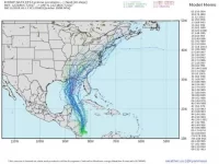
Latest 12Z Euro ensemble members. Gives a better understanding of what areas could be affected later this week. Again, this will change tomorrow. Still too early.
 
Advertisement
View attachment 51076

Latest 12Z Euro ensemble members. Gives a better understanding of what areas could be affected later this week. Again, this will change tomorrow. Still too early.

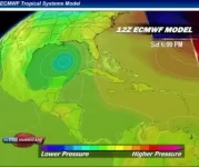
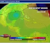
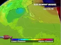
12Z ECMWF has the following timeline:

F446FE20-D268-482B-A3FA-45DCE297F0D1.jpg
05C3BA44-7551-4EFE-81E9-31251900E3BD.jpg
DB99120E-5455-47E0-8FE2-80D8FC0300A9.jpg

Based on this model, from what people are saying the most accurate one in the past, this will not even have any kind of weather impact on Tallahassee until sometime midday Sunday or actually later, possibly the evening.

Is there any reason to cancel this game, or even move it to Friday, based on the available information now?
 
Normally I'd agree but GFS struggles in early stage development (throwing the whole run off after), really need to pay attention to the Euro here.

If we are taking the Euro as gospel, the game will be cancelled.

No, there is still plenty of time for things to change, the ensemble euro members show landfall anywhere from miami to texas at this point. Wait and see. We'll know more tomorrow afternoon at the earliest.

The NHC cone of death is squarely on the pan handle. NHC seems to be completely dismissing the GFS (as you alluded to). The 5 day NHC cone has gotten pretty **** accurate over the past few seasons.

The cone of death had Irma with a hit on the eastern side of Florida 5 days out. When it made landfall the only reason Miami got hit at all is because of how big Irma was. Nate is not expected to have that type of reach.

they were off by 75 miles or so, pretty g@ddam accurate. a wobble to the right, we get nailed. see mattthew, wobbled right and missed us.

75 miles when talking about weather forecasting is within 99% of certainty.
 
Advertisement
i love how this football season has turned every UM (and Arky St.) fans in to meteorologists. We are predicting hurricanes paths and comparing models, measuring velocity and pressures lol
 
Advertisement
One extra thing to add is that (RI) Rapid Intensification is not off of the table. If the system doesn't interact with land it will be sitting over the warmest waters in the basin with little to no shear or dry air. In the short term W Carib/S Gulf this thing could blow up rather quickly (important note: not an Irma) and become stronger than currently forecast by the NHC.
Get a life kid. Don't you have anything better to do than guess at what may or may not happen pertaining to weather and game. You are pathetic. If we play, fine. If we don't play, so be it.

Um....ok? That wasn't a guess or prediction just a real possibility. Carry on with your grouchy *** life!!!
hemsley gets the senior citizen of the year award for that post. and i thought i was one of the senior members of the board.

Must be really old and past his bedtime!.....because I'm a kid at 52!!!

get-off-my-lawn-gif-1.gif
 
Advertisement
Back
Top