New NHC Cone, Tropical Depression 16 forms (NATE)

Dan Sileo JR

Band
Banned
Joined
Aug 2, 2017
Messages
863
205552_5day_cone_with_line_and_wind.jpg

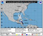
*sigh*, the ASCAT remote sensing system has found cyclonic attributes, forming TD 16 near Nicaragua, soon to become Tropical storm Nate (later today).

I'll reply and edit the post with latest news and thoughts, but for now let's wait for the 12z Euro run due around 2 PM. Like I said earlier, we won't know much about the possible intensity before at least tomorrow afternoon, but the NHC has it as a 80 mph hurricane before a possible landfall as of now.

Louisiana coast to West coast of florida should start reviewing their hurricane plan, just in case.


EDIT with Wednesday 5 PM Cone.
 
Last edited:
Advertisement
Totally different situation category 5 to at most cat 1 storm. The comparison or threat to cancel due to similar situation is ludicrous.
 
Advertisement
Advertisement
It seems like we go through this with every storm with the "let's move the game up" crowd. I'm not saying it doesn't make sense but typically that logic doesn't work for numerous reasons...safety of traveling fans, first responders busy doing more important things, etc...My gut tells me this game isn't going to be played in Tallahassee this weekend.
 
Totally different situation category 5 to at most cat 1 storm. The comparison or threat to cancel due to similar situation is ludicrous.

The effects that Miami felt from Irma were Cat 1 level winds. While we got lucky with missing a direct hit, the damage was still significant. It may be in the best interest to move the game to Friday night, perhaps.


whatever it is they do dear god please don't cancel this game
 
Advertisement
View attachment 50958

*sigh*, the ASCAT remote sensing system has found cyclonic attributes, forming TD 16 near Nicaragua, soon to become Tropical storm Nate (later today).

I'll reply and edit the post with latest news and thoughts, but for now let's wait for the 12z Euro run due around 2 PM. Like I said earlier, we won't know much about the possible intensity before at least tomorrow afternoon, but the NHC has it as a 80 mph hurricane before a possible landfall as of now.

Louisiana coast to West coast of florida should start reviewing their hurricane plan, just in case.

just looking at the wind probability chart and it appears there is an outside chance of TS force winds hitting that area by the end of the game (8pm sat). depending on the next couple of forcasts i think they are going to have to consider friday night as an option.
 
Totally different situation category 5 to at most cat 1 storm. The comparison or threat to cancel due to similar situation is ludicrous.

The effects that Miami felt from Irma were Cat 1 level winds. While we got lucky with missing a direct hit, the damage was still significant. It may be in the best interest to move the game to Friday night, perhaps.


whatever it is they do dear god please don't cancel this game

This.. But Who is casting this voodoo over this game? The one year we have the team advantage along with the better QB.. it might rain (which only helps FSU make this a low scoring messy game) or the game potentially could get cancelled.. (Along with the other things that has happen the past 3 years.)
 
Advertisement
I just feel really bad to those people in Tallahassee. They are going to get wiped out by a Category 5 Miami Hurricane, only to be followed up with a Cat 1 just a day or two later. Best get the womenfolk out of town and batten down the hatches, trailerhassee folk, next step is bend over and kiss your *** goodbye!!
ofMlyM3.jpg
 
View attachment 50958

*sigh*, the ASCAT remote sensing system has found cyclonic attributes, forming TD 16 near Nicaragua, soon to become Tropical storm Nate (later today).

I'll reply and edit the post with latest news and thoughts, but for now let's wait for the 12z Euro run due around 2 PM. Like I said earlier, we won't know much about the possible intensity before at least tomorrow afternoon, but the NHC has it as a 80 mph hurricane before a possible landfall as of now.

Louisiana coast to West coast of florida should start reviewing their hurricane plan, just in case.

just looking at the wind probability chart and it appears there is an outside chance of TS force winds hitting that area by the end of the game (8pm sat). depending on the next couple of forcasts i think they are going to have to consider friday night as an option.

We get tropical storm winds with every afternoon thunderstorm
 
Advertisement
Back
Top