duke4heisman
Let's go Brandon!
- Joined
- May 23, 2013
- Messages
- 9,386
Euro's operational run shifted west overnight. Intensity wise, it could actually be weaker than yesterday predictions because of all the land interaction, and the fact that it still hasn't been able to get its **** together and become an actual tropical storm (to put it bluntly), a weaker system also moves a lot quicker.
Let's continue to monitor throughout the day, but definitely encouraging overnight trends.
As of now score a rare victory this year for the GFS, as the Euro def. caved towards it last night (both location & intensity wise). The 6Z GFS this am shows very little development of Nate. Again we need to look at trends but the last 15 hrs are encouraging.
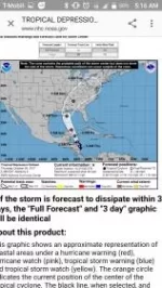
So if I'm reading this right.... there's less than a 40% chance of tropical winds anywhere.... so that means there is no storm in the gulf.
This image, from the same source, has it as a hurricane just off the coast.
View attachment 51011
Uhh no. Look at the key on the bottom... hurricanes are in pink or red. I don't see any pink or red on the map. So... no hurricane.

a change to noon would be the best option, given the timing of winds. the graphic below is helpful to understand timing
View attachment 51120


Even if nate doesnt hit tally a major hurricane is gonna roll thru on saturday and whoop that ***
Even if nate doesnt hit tally a major hurricane is gonna roll thru on saturday and whoop that ***
How many times can we possibly use this joke in one thread?
Even if nate doesnt hit tally a major hurricane is gonna roll thru on saturday and whoop that ***
How many times can we possibly use this joke in one thread?
The real hurricane hits Saturday at 3:30!!!!!!!!!!!!