Suhrthing
Stable Genius
- Joined
- Sep 17, 2016
- Messages
- 24,182
Wrong yet again.
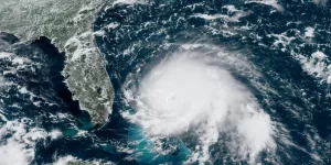
“Dorian is the size of Georgia”. LOL

Wrong yet again.
“Dorian is the size of Georgia”. LOL
Look at this clown thinking cloud circulation is the actual size of a hurricane.
Seriously, do you even have your GED?

Shhh.. this kids trailer isn't getting wiped away by Dorian so it doesn't exist. Lets not spoil his party.Feeder bands. How do they work?
Look at he NOAA map above, I see 'cloud circulation' listed nowhere in their legend. Seriously get back to me if I need to help you out, they even used crayon colors to help decipher it...
You've been through 4... thats cute.Go back into your cabin in North Dakota, you’re talking to an adult that’s been through a bunch of these.
Sorry, but he's right on this one. If you want to define a hurricane by every cloud associated with it, then fine, it's huge. Florida Today is a newspaper and they sensationalize everything in pursuit of clicks.Shhh.. this kids trailer isn't getting wiped away by Dorian so it doesn't exist. Lets not spoil his party.
My back patio on one of them:
View attachment 96267
When you’ve been through several of these, come talk to me you fūcking clown.
Sit your dumb hick *** back down.
Tropical storm winds (39-75mph) extend out 140 miles from the center, as per NOAA/NWS has stated and show above. Thats not 'a little further'. A hurricane's size is defined by the storm its carrying around with it.Sorry, but he's right on this one. If you want to define a hurricane by every cloud associated with it, then fine, it's huge. Florida Today is a newspaper and they sensationalize everything in pursuit of clicks.
Hurricane force winds are very tight around the center. Tropical storm winds extend a little further out. I'm due east of it as well and so far this is a non-event. We've maybe had a couple of tropical storm gusts.
Sorry, but he's right on this one. If you want to define a hurricane by every cloud associated with it, then fine, it's huge. Florida Today is a newspaper and they sensationalize everything in pursuit of clicks.
Hurricane force winds are very tight around the center. Tropical storm winds extend a little further out. I'm due east of it as well and so far this is a non-event. We've maybe had a couple of tropical storm gusts.
Weather channel just said the highest gust they had at Juno Beach was 60 mph. That's a gust, not sustained.Tropical storm winds (39-75mph) extend out 140 miles from the center, as per NOAA/NWS has stated and show above. Thats not 'a little further'. A hurricane's size is defined by the storm its carrying around with it.
Tropical storm winds (39-75mph) extend out 140 miles from the center, as per NOAA/NWS has stated and show above. Thats not 'a little further'. A hurricane's size is defined by the storm its carrying around with it.
Dont get me wrong, the weather channel and its ilk are ridiculous.Meanwhile, Jim Cantore's pointing at a house in Stuart by Bathtub Beach that has the ocean right at the back door. That house has been that way for years, but you get the impression that all that erosion happened from Dorian.
"Typical hurricanes are about 300 miles wide although they can vary considerably in size. The storm's outer rainbands (often with hurricane or tropical storm-force winds) are made up of dense bands of thunderstorms ranging from a few miles to tens of miles wide and 50 to 300 miles long. Hurricane-force winds can extend outward to about 25 miles in a small hurricane and to more than 150 miles for a large one. Tropical storm-force winds can stretch out as far as 300 miles from center of a large hurricane."Weather channel just said the highest gust they had at Juno Beach was 60 mph. That's a gust, not sustained.
This is not a big storm.
Translation go buy more supplies and get all the gas. I knew better than to cancel work the next two days. Only positive is that the lines at Animal Kingdom and Hollywood Studios were way down. You should hear the local news still hyping this thing up even though if you look at the wind forecast for yourself there are no hurricane force winds and no major flooding except in low lying areas which happen on the reg with back to back to back normal afternoon thunderstorm. I repeat this will not make landfall in the us. Check the surf report for OBX, NC and not to mention if the high pressure over the US is pushing it right drier air will wrap into the west side of the storm and all they'll get is the same thing here, a few squalls.From the latest (0500) NHC Forecast Discussion on Dorian:
Key Message
3. The risk of life-threatening storm surge and hurricane-force
winds continues to increase along the coast of North Carolina.
Residents in these areas should follow advice given by local
emergency officials.
Local coastal officials have already started to evacuate some areas; the decision window is starting to close and the optics may drive it in the wrong direction.