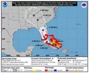
Hurricane Irma

NYT reporting it is lashing Puerto Rico with 185 mile per hour winds, and that it damaged 95 percent of the buildings on the small resort island of Barbuda. One of the strongest hurricanes ever recorded in the Atlantic.

Not true about PR. The most it got on the mainland is like 65 mph maybe a gust of wind a bit more, but overall it moved north and should be completely gone in a couple hours. So far everything good the hurricane eye was about 45 miles from San Juan so we didnt get the 100 mph winds. Some trees fell and small flooding in areas but otherwise pretty relaxed. Our houses are made of cement to withstand huge hurricanes, i even had my backdoor open most of the day without a problem.

We will have to see tomorrow to see the damage but doesnt appear too bad. Culebra did get hit with 100 mph winds but i believe most people evacuated to mainland puerto rico.

Love Culebra. One of the best islands and beaches to visit in the world. Hope the damage isn't too bad.
 
Advertisement
We've lost Johnny Mo, fellas. I'm ready to take this serious now. If Ol' Taddy doesn't make it please tell Jill Arrington that I always loved her.

Screenshot_20170907-205656.jpg
 
The 1:45 AM Euro update was again considerably more westerly than the consensus. Euro runs only every 12 hours.

This time it was slightly more south and west than the afternoon version, making landfall at Cuba before emerging toward southwest Florida. This would leave Miami on the dirty side of the storm but at least spare a direct eye wall hit.

Euro and UKMET apparently are forecasting that a front will shove Irma further south than the consensus models suggest.

Thanks for the continuous Euro updates. Seems as if all the other models have been following suit after these are made
 
The Euro model just altered the path significantly west. Everyone on the weather message boards was shocked. The Euro is now the outlier even though it has been the most accurate by far on Irma so far.

The spaghetti plots place Irma heading smack at Miami but the Euro now prefers an I-75 path closer to Naples. That might spare Miami the worst although it does place the northeast quadrant or "dirty side" toward Miami and specifically the western areas.

The Euro keeps Irma inland up the state including basically direct hits on Orlando and Gainesville. However, the wind speeds would weaken somewhat at that point.

I'm just passing this on because it's a very recent development and not all the official sources including the National Hurricane Center have plotted this shift into their official forecast. The second most accurate model on Irma so far -- UKMET -- had also indicated a more westerly route closer to the Naples area. That model was considered the outlier until Euro reported.

The reference point will be interaction with Cuba. Both the Euro and UKMET have Irma heading over land in Cuba before emerging west. The models that smack Miami directly keep Irma north of the Cuban coast.

I've been rooting for an east shift but either deviation is fine. At this point I'll beg for west.

Doesn't look like the current projection is sparing Miami at all. It shifted west but not far enough, yet.

Nothing is really being "spared"...the storm is three times our size. So if it makes landfall here as a high level 4 with 155 mph winds with a 70 mile long eye, we'll still be faced with 125-130 mph winds and be on the dirty side.
 
Advertisement
To everyone on the board - good luck with the storm. I am in Jupiter, so we won't be getting the worst of it here. But to all those farther south in the landfall area my prayers are with you. My gut instinct is that Cuba is going to take a little off the top end speeds more than what is predicted.

Good luck to all of us in Fl.
 
Advertisement
its looking more likely that this will move more west than earlier predictions. possibly hitting southwest florida head on instead of miami. hoping it keeps moving further and further west. i know its gotta hit somewhere... just hope its not ourwhere.
 
I'm not evacuating Miami Beach. Definitely won't have power for at least a week but took my cars to garages. Praying for the best.
 
its looking more likely that this will move more west than earlier predictions. possibly hitting southwest florida head on instead of miami. hoping it keeps moving further and further west. i know its gotta hit somewhere... just hope its not ourwhere.

I don't trust it.

It's going to hit south Florida head on. Could be anywhere. Miami, SW, Naples, just one little jog at the last minute before landfall will ruin a bunch of lives. Just a matter of who and where
 
Advertisement
Definitely tracking west but obviously still too early that any minor turn flips the numbers back against Southeast Florida.

Screenshot_20170908-111451.jpg
 
Not looking great early this afternoon. The more western tracks require landfall over Cuba. UKMET and Euro were proposing that landfall. Now UKMET steers Irma north of the Cuban coast. That presumably means greater likelihood of a spine track or toward South Florida. Euro will have its next model in an hour or two.
 
Advertisement
Best wishes to everyone down there. Hope everything works out as best it can. Be safe and take care of one another. God bless.
 
Advertisement
Back
Top