New NHC Cone, Tropical Depression 16 forms (NATE)

Why would the **** game need to be cancelled, moved, or anything for a bs *** cat 1 storm that's not going to hit until Sunday morning??

Topography...those oaks & pines don't hold up well to hurricanes. Hermine was barely a C1, and it shut most of Tallahassee down for weeks. And even if they don't get a direct hit, they'll be on the "dirty side" of the storm where the tornadoes spin off from.
 
Advertisement
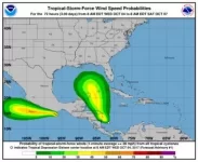
if the below wind probabilities hold, the game is on, plus i just ran into chief hudak and he says it is a go.

144324.webp
 
if the below wind probabilities hold, the game is on, plus i just ran into chief hudak and he says it is a go.

View attachment 50973

So there's a 5% chance of trop storm force winds by Sat 8 AM

Need this thing to continue to dissipate

That's not what that means. As the storm moves closer to land, those numbers get bigger and bigger.

How will the percentage trop storm winds chance increase? That graph is showing, with all the information they have at the moment, the likelihood of tropical storm force winds from now through Saturday at 8 AM. With obviously the areas on or around the eye wall having the highest likelihood of tropical storm force winds. The only way those numbers change is if the projection for the storm changes, not simply because it's moving closer to land. From my understanding at least
 
Advertisement
I think the most likely situation would be the game being moved to tally friday night. Our team leaves friday morning anyway

Coach Cuck will want to game everything to his advantage. Friday would be perfect for him.

That said, we should be prepared to leave for Tally on Thursday.

They have a lot of injuries. Moving the game up helps us. Also dry game helps us.
 
if the below wind probabilities hold, the game is on, plus i just ran into chief hudak and he says it is a go.

View attachment 50973

So there's a 5% chance of trop storm force winds by Sat 8 AM

Need this thing to continue to dissipate

That's not what that means. As the storm moves closer to land, those numbers get bigger and bigger.

How will the percentage trop storm winds chance increase? That graph is showing, with all the information they have at the moment, the likelihood of tropical storm force winds from now through Saturday at 8 AM. With obviously the areas on or around the eye wall having the highest likelihood of tropical storm force winds. The only way those numbers change is if the projection for the storm changes, not simply because it's moving closer to land. From my understanding at least

It's only 5% because they have no idea where it's going to go. But it's not going to stop in the middle of the Gulf. Wherever it hits will have a 100% chance of having tropical storm winds even though that location currently has a 5% chance.
 
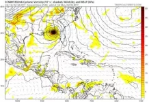
Big change in the ECMWF (euro) operational run, the storm is now projected to be stronger, but moving slower, bringing a landfall in tallahassee closer to 8 AM monday (a full 24 hours after the NHC forecast of the morning)
 
It will be NW of cuba during game time, far enough not to mess with TLH that afternoon. Again, things will change by tomorrow, must continue to monitor.
 
Advertisement
if the below wind probabilities hold, the game is on, plus i just ran into chief hudak and he says it is a go.

View attachment 50973

So there's a 5% chance of trop storm force winds by Sat 8 AM

Need this thing to continue to dissipate

no. according to this, there is a zero percent chance of TS winds on Saturday at 9am in Trailerhassee.

According to the same source, the NHC, they have this thing projected to be a Cat1 just off the coast of the panhandle Sunday AM. I think this means something different that what you're interpreting.
 
Back
Top